Showing posts with label travel. Show all posts

Sunday, April 13, 2014

To the Caribbean 2014

     Yes, we did get out of this area for a short while this winter. We took our second cruise to the Caribbean in as many years. This time we boarded the Oceania Riviera in Miami and headed out into the northeastern Caribbean. Oceania cruises are known as "foodie" tours. Indeed, the food is definitely a couple steps above the typical. Oceania's two larger ships, the Riviera and the Marina, each also have a wonderful library, board game or bridge room, large lovely lounge on top up front where every afternoon wonderful 4 PM teas are served to the music of their live string quartet. The ship has a wonderful spa, private spa deck for "Veranda" guests and above. There is a coffee bar where baristas stir up excellent brew. I particularly like the Artist Loft, with art classes directed by a resident artist. In the past my main media for art was water colors and water color pencils. But on this cruise our art teacher was a proponent of acrylic and favored the use of only a palette knife. Sure makes clean up easier. For me this was very good practice with this media and method. But one of my favorite pastimes was sitting on our veranda while we were at sea, staring down into the deep indigo waters. We have visited the Atlantic, the Pacific, the Southern Ocean, the Mediterranean, and the Black Sea and Baltic Sea, but none of those waters compare to the indigos and close to shore the various shades of turquoises that characterize the Caribbean. I can sit for an hour just watching the surf as it rolls off the hull of the ship, creating wonderful swirlings and gorgeous turquoises. Once in a while a group of small flying fish will break out of that roiling swirl, at right angles to the ship's path, I am sure, convinced that we are a very large predator.

Our ship,, the Oceania Riviera at Grand Turk cruise ship port.
    Our first port of call was Grand Turk of the Turks and Caicos Islands. This island is quite small and only has one pier. We were the only ship in port. And the port is currently incapable of taking some of the very large cruise ships which I think is a plus. Unfortunately they are gong to add a new pier system which will enable several ships to visit at one time. I think that may destroy some of the charm of the island. The island currently does have a nice developed reception area with nice beaches on each side of that one pier. And there are some very nice boutique shops in this cruise center as well. One of the shops surprised me; it was an Israeli art shop with some Israeli paintings, as well as menorahs, and metal hamsa and chai jewelry and mezuzahs. My husband arranged for us to have a guided tour of the island on of all things -- ATVs. This is the first time we have driven these unique vehicles. Our guide could tell that we were rather inept and kept us mostly on the regular surface roads of the island. Fortunately most of the ship's people just shopped in the boutique stores and used the lovely beach. The island roads were pretty empty. But there was a nice lighthouse to see, some Caribbean flamingos, and there are replicas of the John Glenn Gemini caqpsule around the island because he landed in the waters off the Grand Turk.

Grand Turk Cruise Center beach right next to the pier next to our ship. Many passengers spent the day right here. 
         It was a view of the lovely beach on Grand Turk that I used as the subject for my main acrylic painting of this trip. I wanted to show the blues and turquoises of these Caribbean waters. Here it is:
My version of the Grand Turk beach sitting in a beach chair on the shore side.
Old San Juan
Latte at Cafe Prieto in Guavate.
       Our next port of call was San Juan, Puerto Rico. I visited this island years ago on a pharmaceutical junket and we had rented a car and drove all over the island then. There really is quite a bit to see here. This time we just hired a guide to show us the two forts and give us some history that we had forgotten from the last visit, and to show us a little bit of San Juan. Then he drove us up into the hills behind San Juan to a place called Guavate, famous for Le Choneras. Lechon is pig roasted on a spit. And a restarant that roasts and serves this pig is called LeChonera. The whole name of our destination  restaurant is LeChonera Los Amigos but there are many of these places in Guavate. These are generally rustic restaurants where people dine on picnic tables covered by oil cloth. The meals include the pig (or roast chicken), yams or potatoes, beans, fried plantain, and breads. The food was delicious. It was a Tuesday and it was not very busy at all, so the owner spent some time sitting at our table. He sounded like he was a displaced American by his lack of any accent. But the best part was the cup of coffee afterwards in a neighboring little coffee shop, operated by the owner's wife. This coffee was made from a locally grown premium coffee bean. And of course I had it as a latte. It was absolutely delicious, and fancily prepared by a talented barista. We sat on the deck in back overlooking a deep and lush ravine. It was a great ending to our tour of San Juan.

Leaving the port of Grand Turk.

This is a Royal Caribbean ship called Oasis of the Sea. It carries over 6000 guests 


 Our next port of call, St Marten, is an interesting island. Half is French and half is Dutch. The French side used to be the destination of most tourists, but the local French government decided to go along with the French stand during the US First Gulf War. They voted to boycott all US products and to discourage US tourists. Their efforts succeeded and basically their tourism, with the exception of restaurants, has failed. Their hotels have been turned into rooming houses and condos. Many beautiful big hotels had become totally empty relics. Some still stand empty and deteriorating. All cruise ships now land on the Dutch side which has expanded its tourist facilities accordingly, especially attracting small boating operators who travel from island to island, in addition to the cruise ships. People still take a day trip to the French side, so restaurateurs still do OK there. The island has one famous road along the beach where the large jets landing strip starts just at the edge of the road. People love to sit on the beach at the pilots level as these planes come in. Definitely hard on the hearing.
Peaceful afternoon at the beach; plane after plane coming in just like this.

      The next port of call was St. Barts. We had been their during last year's cruise when we toured the island. We knew that the boutiques just ashore were quite expensive and limited and we were not in the mood for beaching it, though the beach right off the pier is very nice. We decided to just stay aboard. In the afternoon I had an art class to attend anyway, and we were painting for a couple hours.
 
Tortola town, on Tortola of the British Virgin Islands.

Lots of small islands around Tortola.

 I liked Tortola of the British Virgin Islands. We had a nice tour of the island, viewing its beaches and driving to high points in the mountains in the center of the island for overlooks. Tortolas is surrounded by many small islands that welcome visitors. There are a lot of Americans that go to Tortola and spend time. We had lunch in a small outdoor restaurant that was situated among some of these American second homes and the owner of the restaurant was herself an American. It is nice that English is spoken here. I could actually see myself with a second home on this island in particular.

Historic Old Santo Domingo, capitol of the Dominican Republic.

     Next was the Dominican Republic. I think many people have formed an image of the DR which is similar to Haiti. But the DR is definitely different.It is the fourth largest economy in the Caribbean and Central America combined. Many incomes are in the area of lower middle class. There is poverty but it is in the rural areas. There is also crime and the Dominican Republic has been criticized for being too lenient on homicidal crime. Also the South American drug cartels are purported to launder their money through the Dominican Republic, creating corruption. But the infrastructure is good. And tourism has created various protected enclaves on the eastern end of the country and to a lesser extent in the northern central area. Also ecotourism is gaining a foothold and the DR has set aside several large national parks in the central highlands. Our ship docked at La Romana which is located within one of those tourist enclaves. I think most of the ships passengers utilized the beach, the local shopping area, or had signed up for ship excursions that took advantage of the local Caribbean waters. We took a different path and headed for the taxi stand. We were the first ship passengers to arrive there and we saw only two taxi vans. We asked what it would cost to drive to Santo Domingo, the capitol, a distance that would take about an hour and a half. One driver answered us quickly in perfect English. The other driver did not speak English. So the English speaker said "I guess I am your man." It turns out that he had lived in the United States, in Florida for about 8 years. He gave us a safe drive to the capitol, a small amount of information and he put us with a walking guide of the Old Town of Santo Domingo, which has many interesting historical buildings, churches, and shops. There are buildings here from the 15th century because this is the area that Columbus chose to develop, at that time, to become capitol of Hispaniola.
      I wanted to purchase a necklace of larimar beads, which is only mined in the DR. This elderly walking guide got me to a shop where I was able to make my purchase, adding another piece of jewelry to my collection of pieces from around the world. We enjoyed a nice lunch, and then drove back to La Romana and headed to the ship. In all it was a very nice and successful day. We were glad we had taken the opportunity to get out of the tourist enclave and see what the DR was all about.
A boulder of pectolite containing considerable larimar effused through it.
My larimar bead necklace. 

     I want to fill you in a little about this stone -- larimar. In 1916, a local priest asked the government of the Dominican Republic for permission to exploit this stone and even start to mine it but was refused. Then in 1974, a local resident and a Peace Core volunteer found pebbles of the stone that had washed down into the estuary of a stream that originated in the nearby hills and mountains. These two succeeded in getting permission to mine the material and others tracked down the vein of rock where this substance originated. The stone is really taking off in popularity throughout the Caribbean and is even being sent elsewhere around the world to be used in jewelry. The name was created by that local rediscoverer of larimar as a combination of his daughter's name, Larissa, and the Spanish word for sea, mar.  Pectolite is an acid silicate hydrate of calcium and sodium. Pectolite is found in many places around the world, but only in the Dominican Republic does this stone contain the blue color, which has some of the calcium replaced by copper. Geologically, the surrounding stone or pectolite was volcanically created but had holes and cracks in it which were later filled by the blue copper containing silicate creating this stone. Indians in the area had long found pebbles of this blue mineral among beach stones, having been tumbled and polished as they were washed down the hillside and finally onto the beach near the source mountain. Now the original mountain has been found and about 2000 vertical shafts penetrate it where this stone is mined. Apparently there are also a lot of fake larimars, some plastic, some other bluish minerals, especially being sold by vendors on the beaches of the DR .But there is an interesting test one can carefully perform. If you hold the beads or pendant of larimar in a match flame for a few seconds, it will remain cold to the touch afterwards. Plastic of course would melt and your vendor would probably not let you do this. But you must be careful in the case of beads or a strung pendant to not hold the flame near the stringing element for that is often plastic and would then break and release the beads all over the ground. How embaressing! Where I bought this necklace, there was a guarantee of authenticity and there was actually a boulder of larimar there on the countertop as well as boulders for sale. My nice graduated bead necklace cost $300. This is a somewhat soft stone and also in heat and high light, the blues may fade so it should be kept in a cool dark place when not being worn. I especially like how it warms up over time as it lies against the wearer's skin.
 
The trained marching flamingos at Nassau Zoological Gardens and Aviary.

  After a day at sea, we put in to the last port of call, Nassau, of  the Bahamas. We had arranged for a driver to meet us and take us around the island. The first site you see from the ship is the huge and familiar Atlantis resort, for which we see many advertisements on TV. One of the ship's excursions included a tour of the Atlantis and its many different campuses. We had no interest in this and instead saw the rest of the small island. I was surprised at the many lovely streets, roads and the growing resort communities. The Chinese are building a huge resort hotel which is supposed to rival the Atlantis. The port at Nassau can handle at least 8 ships at a time and it can handle the huge Allure of the Sea, sister ship to Oasis of the Sea by Royal Caribbean, which was by the way in port while we were there. Wow, what a ship. Its passenger count is 6200 while our ship has a lowly 1200 passengers on board. We certainly prefer the latter. In fact we even prefer two other ships in the Oceania line, the Nautica and the Regatta which only have 600 passengers.
Leaving Nassau, we say good bye to those wonderful turquoise waters of the Caribbean and it's back to Miami for us.
     

Saturday, December 28, 2013

Another great link: Walking Humanity's footsteps.

     One man, one journey, 7 years, 21,000 miles.

     We have traveled a lot as you can tell from my blogs. But there are certain places that we will not go for several reasons. One is that we are getting older and we need some medical providers nearby on our trips so we have to stay in fairly civilized regions. Secondly, my husband is a sabra, a born Israeli and therefore there are some countries that we will not be able to travel to due to basic danger to us. So there will be many parts of this earth we will not be able to reach, and many stories about meeting people that we will not be able to tell.

     Now I have found a replacement for these places which we will not be able to visit. The National Geographic Magazine of December this year begins the story of Paul Salopeck, a journalist who plans to walk the 21,000 miles from the birthplace of humanity in the Great Rift Valley of Ethiopia, over a seven year time period, following the footsteps of 60,000 years of human beings' diaspora. The first article to me was mesmerizing, his walking with a guide, two camels and their "mahouts" (a Southeast Asian word for elephant handlers)  out into the Afar dessert from Herto Bouri, Ethiopia. This location is the site of the Middle Awash Project, an archaeological dig, really a human boneyard, where some of the oldest human bones have been found. Paul and his camel handlers and another local who was his logistician then crossed the Afar desert and reached the Gulf of Aden. There is a map in the National Geographic which shows Paul's planned route, all the way around the world to Tierra del Fuego at the tip of South America. The fascinating thing is that there is a website called outofeden.nationalgeographic.com in which you can follow Paul's walk over the next 7 years. You can follow his dispatches on Twitter:@outofedenwalk. I am excited. These links will allow this peripatetic author to travel to parts of the world even I could never go to and also to view parts of the world where we have been through this journalist's eyes. And I can do this from my lounge chair. Wonderful!

     Paul is making dispatches every 3 to 4 days with photos, often with videos. The URL for the first of these National Geographic dispatches is: http://outofedenwalk.nationalgeographic.com/2013/03/26/the-glorious-boneyard-a-report-from-our-starting-line/
Paul Slopeck has already been walking since January 10 (my birthday) 2013. He has just now in December, 2013 walked into Jordan from Saudi Arabia. There are two sites where you can follow him online:
The National Geographic site above: http://outofedenwalk.nationalgeographic.com/2013

The second site includes a small video at various milestones, an interview with the closest human being at that milestone. The walk has now reached 16 milestones. This site has more structure designed for teachers and small children. This website is: http://www.outofedenwalk.com/

There are also various offshoots and articles written about these places through which Paul is walking. This undertaking of walking 21,000 miles in 7 years is funded by National Geographic Magazine. There have already been some TV stories about it and stories written in various local newspaper publications. There will no doubt be much more as time goes on.

I recommend visiting the two websites most recently listed above. And if you want to start from the very beginning, (A Very Good Place to Start), I suggest using the first URL above which describes the Middle Awash Project, an archaeological dig which has discovered the oldest hominid skeletons so far found in the world, dating back 4.4 million years. As I indicated above, Paul Salopeck chose this site to begin his mind bending long trek because it was as close as our knowledge of early human history can put us to the "Garden of Eden."

It will take a while for you to just catch up to where Paul is now in Jordan, but it is worth reading all the comments that people have left. Some are inane and can be skipped but often Paul actually answers a comment from wherever he is that has cell phone connections and he often adds wonderful little tidbits to his more formal dispatch. I can identify with him trying to find a cell phone connection in the wilds of Ethiopia and the Saudi dessert. During our trip to Kenya and Tanzania, we often stuck our phone into the air to try to get a few bars of signal. And even in the middle of the Serengeti National Park, the guides knew where to stop for a possible connection. They had phone calls to make and we occasionally used the opportunity to post a text on our travel journal.

I am planning on following Paul on his long journey for the next 6 years. If you haven't picked up the December issue of National Geographic, I suggest you do so and read the opening article about his trek and view the magnificent photos.

In the spirit of the Holiday Season, here's hoping that our journey "Out of Eden" will lead us toward world peace and understanding between all the great religious traditions.

Sunday, December 8, 2013

Mystery Photo #24: The city is Moscow, Russia.

 
   Probably the distant church gave you the clue you needed with its "onion" domes. Yes the city is Moscow, Russia, and we are looking at the 350 feet high monument to Peter the Great which is set in the confluence of the Moscow River and the Vodootvodny Canal in the middle of Moscow. A Georgian designer by the name of Zurab Tsereteli erected it in 1997 to commemorate 300 years history of the Russian Navy, established by Peter the Great. It is the 8th tallest statue in the world, made of stainless steel, bronze and copper.
      And it is a source of great controversy in the city of Moscow. First it has been voted one of the 10 ugliest monuments in the world. Its base would seem to be a towering wave from which the bows of several smaller ships poke out. And riding the top of this wave is a lifesize sailing ship with the sails furled. Standing astride the bow is a giant Peter the Great holding a golden map up in his right hand. He is wearing clothes almost looking like a Roman soldier, and totally out of sync with his time period. The Moscovites wonder why in the world it would be mounted in Moscow when Peter the Great hated Moscow and moved his capitol to beautiful St. Petersburg.
The statue in the near distance, from a nearby park.

     And then there is the story of the designer. Apparently he was a favorite of the then Mayor of Moscow, Yury Luzhkov who gave this artist several municipal commissions, among them the Cathedral of Christ the Savior which you see in the background of the photo of the Peter the Great statue, to the left. The story is that this statue is based on a design to commemorate the 500th anniversary of the first voyage of Christopher Columbus to the New World in 1492. Hence the ship is possibly the Nina, or the Pinta, or the Santa Maria. But no one in America would purchase and commission the statue. A similar Columbus statue was eventually sent to Puerto Rico but it was never assembled. Of course, designer Tsereteli denies that this was the Columbus statue that was repurposed to a Russian theme. It is a fact that as soon as Mayor Luzhkov left office, Moscow tried to send the statue to St. Petersburg, but that city also refused it. And so it still stands on the Moscow River.
     I recall when our guide in Moscow pulled up along the Moscow River to show us this statue close up. He made some slightly negative remark about this statue which I didn't understand at the time because I had not read of this controversy. I can only say that from close up and from the near distance it is impressive to the eye. But I can see some of the issues. It might be like the blue working man's shirt sculpture, designed by conceptual artist Dennis Oppenheim, that was supposed to be mounted on the corner of a parking lot down at our airport, Mitchell Field, in Milwaukee. Some thought that this huge translucent shirt denigrated the city's labor worker past. However, the artist insists that was never his intention. He had many other successful artistic installations that especially in his later years championed the human figure. But in Milwaukee, this particular design was so controversial that it never made it. But apparently neither did this Peter the Great (Columbus) statue at several places.
    
The model for the proposed Mitchel Field parking lot "blue shirt" sculpture.


     Near the area of the Peter the Great Statue, between the Moscow River and the .... Canal, and south of the Kremlin, is a small pedestrian park called Bolotnoya Square. Along with a fountain and a typical 'man on a horse' statue, there is a famous sculpture group placed in the square in 2001 called The Sin Monument, or Children Are the Victims of Adult Vices by Mikhail Chemiakin. In the center of the grouping are two children covered with gold tone foil, and around them are aligned fairly large sort of scary statues depicting various adult "sins." The children have no where to turn because every adult figure is guilty of some flaw. And in addition, they are playing "blind man's bluff" , ie blind folded so they will not be able to see the obvious signs in the adults that show their flaws. When we visited in .... there were still a lot of people visiting this sculpture grouping. I have a photo of the whole grouping below. Here is a link of a site that shows each individual statue with great detail.
 
Broad view of "The Sins Monument", Bolotnoya Square

A closer view of the center of the grouping with the children with blindfolds.
    
Ludzhou Bridge "padlock" tree.
     When we visited Moscow, we noticed all the wedding parties at almost every tourist site: the Kremlin, St. Basil Cathedral on the Red Square, the nearby Church of Christ the Holy Savior, the view over the city, from the University of Moscow, and last but not least, Ludzhov Bridge across the Moskva River. For many decades, newly wed couples came here and put a padlock on the rails of the bridge, possibly recalling a past custom where newlyweds were locked into the parents' barn to provide privacy on the wedding night. These padlocks were meant to show the total locking commitment of the new couple. Once the padlock was placed on the rails, the key was thrown into the canal water and the union could only supposedly be dissolved by one of the party diving to the bottom of the cold polluted Moskva River to retrieve the key to their own lock, of course, next to impossible. Over the decades, so many rusted old locked appeared on the bridge that it looked like a junkyard. Therefore city authorities cut the locks off the bridge rails and erected "padlock" trees on the bridge and later as the need arose, along the promenade along the River. These padlocks have appeared elsewhere as well, for example on other bridges, and on the railing surrounding the Cathedral of Christ the Savior, but at many of these other sites, the locks are cut off as soon as they are placed. It is rumored that so many keys have been thrown into the River here along with champagne bottles and glasses, the river needs to be dredged regularly to provide passage for the river tour boats that pass here. To the left is one of the Ludzhov Bridge "padlock trees."

Muzeon Park of the Arts: central statue of Lenin, surrounding busts of Stalin,
and  symbols of Russia in the background.
     Also in this downtown area is a very interesting park. Our guides told us that in English it is known alternatively as the Park of Fallen Heroes, or the Park of Fallen Monuments. In the early 1990s after the fall of the Soviet Union, there were many movements in  Moscow to remove statues of Lenin, Stalin and other Communist leaders from parks, square, and traffic circles in the city. Interestingly even recently there was a proposal in front of the Russian legislature to remove all these statues throughout the country. There are a lot of Stalin and Lenin statues still around the country and the proposal said the cost to keep these statues up could be spent on parks and other amenities for the people. Of course, the Communist party did not like this and so far no law has been passed. This Park is really called Muzeon Park of the Arts and is on property adjoining the Krymsky Val building shared by the Tretyakov Museum of Modern Arts division, and the Central House of Artists. Below are some other photos from Muzeon Park.

Krymsky Val building of the Tretyakov Art Museum, adjacent to Muzeon Park.

Lenin in the center, small Stalin bust to left, Lenin bust to right, and Russian
emblems to the far left, in Muzeon Park.


In the center is a wall created by placing heads of fallen statues in a wire cage
to create a wall. There are several walls like this in Muzeon Park.
Statue of Stalin without its pedestal in Muzeon Park.

     There is also quite a story about this now famous church, across the Moscow River and a few blocks southwest of the Kremlin. It is the modern church called the Cathedral of Christ the Savior, building initiated in 1992 and consecrated in 2000. At 338 feet high, it is the largest Eastern Orthodox church in the world. Initiated in 1812 by Alexander I, whose architect patterned it after Hagia Sophia in Istanbul, and further changed and commissioned by his successor brother, Nicholas I, it was finally finished and consecrated in 1883. It was reportedly a remarkable structure with huge marble freezes which commemorated the defeat of Napolean and other historical events in the Tsarist Russian history. However when the Communists took over, it was regarded as a waste. The government needed the value of the gold which covered its domes, which was first harvested. The Cathedral itself was dynamited to rubble in 1931 at Stalin's order. At least many of the detailed marble freezes were removed and are now in a museum. Stalin intended to build the Palace of the Soviets on the site, as a monument to socialism. However, World War II interfered and that building was never erected. Instead the large hole left by the demolition was turned into an the largest outdoor swimming pool in the world. Our guide could remember swimming there in the 1960s and 1970s. After the fall of the Soviet Union, the Russian Orthodox Church sought and won permission to rebuild the Cathedral of Christ the Savior based on the original church. Funds were collected from the people all over Russia with 1,000,000 Muscovites contributing. The first architect, Denisov, however, was relieved of his duties and replaced by Zurab Tsereteli, a familiar name to you readers, as he is the designer of the Peter the Great statue which was the mystery Photo. True to his nature, Tsereteli made several modifications to Denisov's design, which included replacing the marble freezes with modern bronze ones. This Cathedral now has the only such bronze interior elements like it in any Eastern Orthodox Church. Truly this Cathedral is magnificent and remarkably suitable as the national Russian church and now centerpiece of the Russian Orthodox sect.

Cathedral of Christ the Savior

Gives you an idea about the massive nature of this church.

The Kremlin Wall from outside Red Square
Famous Saint Basil's Cathedral, now a museum.

Clock tower of the Kremlin

St. Basil's Cathedral from inside Red Square
 

Kremlin wall from inside Red Square; Lenin's tomb to the right in mid distance.
      We made another stop while in Moscow, not quite downtown, but still worth a stop. This is the grounds of the All Russia Exhibition Center. This site was a gorgeous Exposition in 1939 with magnificent buildings showing off what Bolshevik Russia and the Soviets had accomplished by this time. It fell into disrepair but in 1992 at least some of it was resurrected. The grounds now house an amusement park. But some of the old architecture still shines through.


The huge gates of the 1939 Exposition Grounds.
A wonderful fountain showing peasant women in native costume. It was not
running when we were there but apparently runs in the summer.


       All in all, I found the city of Moscow very unique, and really quite beautiful in many areas. Of course, some of the interest remains historical when the Kremlin was the center of government of our Cold War Enemies at the time. Now it is clear that Moscow has joined the world of fashion, modern architecture and great restaurants, unfortunately catering to very expensive tastes. But I would go back. It was in many ways a magnificent trip, both to Moscow and to the reset of Russia that we visited: Volga River cruise, Yaraslavl, Kitzi, and St. Peterburg.


Friday, November 29, 2013

"Packing for the Road"

From Journal of American Medical Association Nov 27, 2013: Volume 310, #20

Packing for the Road
by Corey Fogelmanm MD

Packing for the road is a way
Of lightening the load. So much
That crowds the mind can at
Last be left behind. Yet if we
Leave what gimbals the keel, how
Off-center the chest can feel.
Perhaps we are nomads at our
Core, connected to what's
Essential and nothing more.

     My husband and I are seasoned travelers as you can tell from the many travel blogs on this site. Over the years of our peripatetic activities we have slowly learned how to pack very very light.

Sunday, November 24, 2013

The Masai: National Geographic Info

     The new National Geographic Magazine arrived in the mail yesterday. My mother subscribes to the magazine for me and I usually read through the entire magazine. I love the reports about strange places and strange nature that my husband and I have often seen in our travels. There was a little page blurb in the December magazine showing a Masai junior warrior doing the famous Masai jump. (See my post from 11/7/2013 on this blog.) But this photo is accompanied by a very interesting story about the Masai and their worldwide fame.
     Surprising to me was the fact that worldwide there are 80 products which include even expensive items such as cars, clothing and jewelry that carry the name of this tribe. I have not seen advertisements for these products but I would guess that images of these famous warriors are used to sell these items. If no images, for sure the worldwide known stature of this Kenyan and Tanzanian tribe are used. But as indicated by Isaac Ole Tialolo, speaking for the Masai Intellectual Property Initiative, no one has asked the Masai's permission to so use their name, reputation, and indeed their branding to sell these products.
     This Initiative organization is now reaching out to all the clans of the 3 million strong Masai nation, to elect an authorizing council to review requests to use this Masai branding and to review those products that already use the name. The plan would be similar to what our southwestern Navajo have done. Any merchandise that has been approved by the Council would bear a certificate that it is either manufactured and produced by Masai themselves, or their design and name has been officially approved by this Initiative. "As the cultural owners, we want respect," says Tialolo. "We want to protect our heritage, our name, our image."
     Article by Johanna Rizzo.


Here you can see the beadwork that the warriors
wear, around the neck, the wrist, and the waist. These
two guides are serving us the morning coffee break.
They are also wearing the olive green fleece sweaters
 of the Kenyan National Guide Service


Here is the rustic Masai beadwork store at Porini Amboselli Camp.
The beadwork inside the Masai store.

     When we were in Kenya and Tanzania, we purchased a few things that were definitely of Masai origin. At Porini Amboselli Camp there was a small rustic store which was selling particularly beadwork done by the women of the local Masai village. I actually purchased a beautiful orange multistranded necklace which I like very much for just the equivalent of $11.00, and my husband got a beaded collar. As you can see from the accompanying photos the Masai warriors all wear many forms of beaded work, but mostly around the neck and around the waist. These items could easily be branded Masai just as the Navajo silver jewelry is branded.

     Also the Masai make walking sticks and shields. Of course they also make their famous spears but I didn't see any of those for sale in the Masai store at Porini. There were some shields for sale. And in other souvenir shops along the way there were shields, and drums which might have come from some of the Masai tribes.


More beadwork.

African shields, maybe of Masai design.

Drum set.

        
This is the necklace I purchased at the Porini store. It is just
made of glass beads and brass couplings, but it certainly
involved a lot of hours of labor to string all of these beads.
I found it quite attractive and am wearing it often.

Thursday, November 21, 2013

Mystery Photo #24 First name the city.

     This photo has several related questions depending on your astuteness in identifying this place. First name the city, country. Then try to name the monument, which is really very impressive just as this photo suggests. Then try to name the white building in the distance to the left. This distant building probably provides an important clue as well. When I post the answers I will include some other nearby tourist sites.


Friday, November 15, 2013

Mystery Photo #23: Assisi, Italy and Mount Tabor by our connection.

       The Mystery Photo #23 depicts the Basilica of Saint Francis of Assisi  An aerial view of the Basilica appeared on this 1920 travel poster in the photo below to the right. But this town of 25,000 people with 3700 residents within the surviving medieval walls of Old Town contains many other churches and landmark sites. Below on the right is the Roman facade of the Temple of Minerva converted in the first centuries of the Common Era to a Christian church. The bell tower on the right is called the Municipal Tower.


Wednesday, November 13, 2013

Ground Zero Now and downtown in New York City!

The High Line
       After our niece's wedding in May we spent a couple days in New York City. We stayed at the Hilton Hotel on 8th Ave and 48th Street so we would be near our shows around Broadway. But on the second day, a cousin who is native to the city picked us up and decided to show us a few sights we had never seen. We headed downtown by car.
        
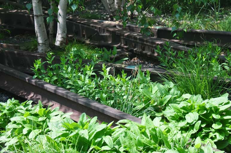
     . We parked the car and walked up onto the High Line walkway that was once the elevated train down there, a portion of the old West Side line of the New York Central Line spur. Briefly the history of this line began in 1929, but with the shift to transcontinental trucking in the 1950s, this line slowly lost one of its chief commercial supports. The southern end of the line was demolished in 1960. Though trains operated on parts of the line until 1980, it was closed from that point until 2009. Instead of tearing down these elevated platforms on which trains used to run, it cost less to develop these old track platforms into gardens and walkways. The planting beds are the old track lines many with the rails still in place. The plantings are mostly native often showcasing the plants that had colonized the old right of way. The hardscape in addition to walkways and plazas includes built in benches, chaise lounges and in one place chaises that roll on the rails to take advantage of the sun at different times of the day. Many people utilize these irregular green spaces for lunch, for reading, for sunning, or just for walking from one place to the other. Food vendors and other vending kiosks have begun to occupy spaces along these walks and there is an atmosphere of serenity and healthy activity. And the green walkways are actually safer than the street below. Although originally no one could explain this, it appears it is because these walkways are visible from the buildings that adjoin them. Therefore when you walk these spaces, you are never alone as you might be on the street below. It is along one of these green areas that the Whitney Museum of Art is building an annex, instead of adding on to its museum in Midtown. Real estate prices near the High Line have risen and much high end living space and commercial space has moved in nearby. The High Line now stretches from 3 blocks south of 14th Street (Gansevoort Street) to 30th Street. There is a Stage 3 currently under construction at the north end which will extend in a sharp turn west and then north to 34th Street.  Here are some photos of these spaces.

    
The Standard Hotel is a new property built over the walkway.
The IAC Building (at left) by Frank Gehry, located at 18th Street.

The Chelsea Market Building, once the National Biscuit Co. factory.

Looking east toward Lower Manhattan.

Looking west across the Hudson from the High Line.
  
The plantings among the remaining rails of the old West Side Line.

     Near this green space is the famous Chelsea Market of Lower Manhattan. In fact the High Line actually passes through the 2nd floor of the Chelsea Market building. What a colorful place the food concourse is. If I lived and cooked in New York city I would definitely make this at least a weekly stop. There are multiple shops and boutiques in addition to all the food markets. Restaurants located on the food concourse cooperate with the food markets so that the freshest produce, meats and sea food are readily available for both retail and food preparation. And all spaces and corridors take advantage of the character of the building itself with the visible infrastructure. The main building pictured below was once the National Biscuit Company factory, the makers of Oreo Cookies.  Many of the original brick walls and arches of the building add the charm of this venue. Across 10th Avenue, accessed by a pedestrian bridge, office space is available which has offered space to several media titans: Oxygen Network, Food network, a local cable TV station, recently Google and other media companies.

Between 14th and 15th Street, the tracks of the High Line run through the
second floor of the Chelsea Market Building.

Inside Chelsea Market building.

A few photos from the sea food market.


Another long corridor inside Chelsea Market building.
     I was prompted to include these photos from our May New York visit now, because just a few days ago, the lighted spire was placed atop the Freedom Tower, the tallest building in the United States counting the spire as was decided by a so called "Tall Building Council" just today in Chicago. It has been 12 years since crazy militant individuals in the name of Islam, having hijacked that religion, flew hijacked planes into the World Trade Center in New York city.  I was so refreshed by the remarkable changes that have taken place in Lower Manhattan. The area is booming. There are all sorts of new buildings down there which have sprung up to fill in the void left after that devastating disaster of 2001. Our photos show the beauty of this building and of this area of the southern tip of Manhattan. There is a wide boulevard with a lot of green space between the lanes of the boulevard. It stretches from east to west across the island down there with Freedom Tower serving as its axis.
The spire being placed atop the Freedom Tower.

Freedom Tower


The base of Freedom Tower


All new buildings around Freedom Tower

Freedom Tower in May; it is now complete.


     One of the great characteristics of the Big Apple is its neighborhoods. Our cousins then drove us to their apartment in Forest Hills, Queens. Near their apartment building is an area of brick homes dating to the 1910s which has a flavor unlike what you would expect in any of the boroughs of New York, but instead seemingly would be more at home out on Long Island. This area is entered at Station Square just off Queens Boulevard and is called Forest Hills Gardens. This lovely area was a planned community started in 1909 to provide homes to upper middle class people who wished to commute to Manhattan. The Tudor and Colonial homes that characterize this area have been lovingly maintained and now sell for anywhere from 1.5 million to as much as 4 million. Surrounding the Forest Hills Garden area is Forest Hills itself, now the most exclusive area in Queens for apartments and condominiums and some single family homes as well. Forest Hills was once the home of the US Open Tennis Championship at the West Side Tennis Club, until in 1977 the tournament moved to Flushing Meadows. Here are some photos of the single family home areas of Forest Hills  Gardens.

Station Square entrance to Forest Hills Gardens


       Our cousin lives in one of the apartment buildings of Forest Hills. Below he is showing us his building and inviting us in for lunch. We ended the day with a very enjoyable social visit at their apartment. They love their city and we were glad they took the time to show us some of these little visited areas of the Big Apple.